Learning Objective:
- The students will get an idea of the history of Medieval Assam (13 Century)
- The students will get an idea of map of Assam (geographical position of Assam in Medieval period)
- The student will get a basic concept of the interstate relationship with Assam in medieval period
| Day-1 Time: 20 minsActivity 1: The students will write in their copy about what they know about the history of Medieval Assam and will share it with the teacher/guardian. Resource: The students can click the link to watch the documentary film on Assam history if they wish to. Time: 30 mins Activity 2: The students will scan the QR code given in the textbook and go through the text. They will draw a timeline on their copy where they will write the ruler name, ruling period and the significant events of that ruling period, (The students should use the sample timeline as an example and not to copy paste or similar design) and will share with the teacher/parents. Resource: Example of timeline:
The students can click the given link (a), (b) for under the chapter: Chapter explanation in Assamese: Chapter explanation in English: |
| Day-2
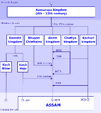
Time: 40 mins (20 mins for each activity) Activity 3: The students will search internet/ reference books to get the map of Assam province in medieval period. They will define the difference between the map of Assam present time and medieval period and will share with the teacher. Resource: Google for 13th century map of Assam/ Diksha app Activity 4: The students will write a documentation on the rulers of Assam, how it changes over the time, and its effect on the interstate relationship. |
Click here to download the lesson plan
Prepared by: Dimbeswar Sarma, Namati Vidyapith Higher Secondary School, Assam;
Edited by: Srabanti Basak; ITE resource Team, TISS, Mumbai
Helpline Number : +91 70028 25970, +91 91018 89733